
The Early Okanagan
Historic and Geographic Information about Penticton and the Okanagan Valley
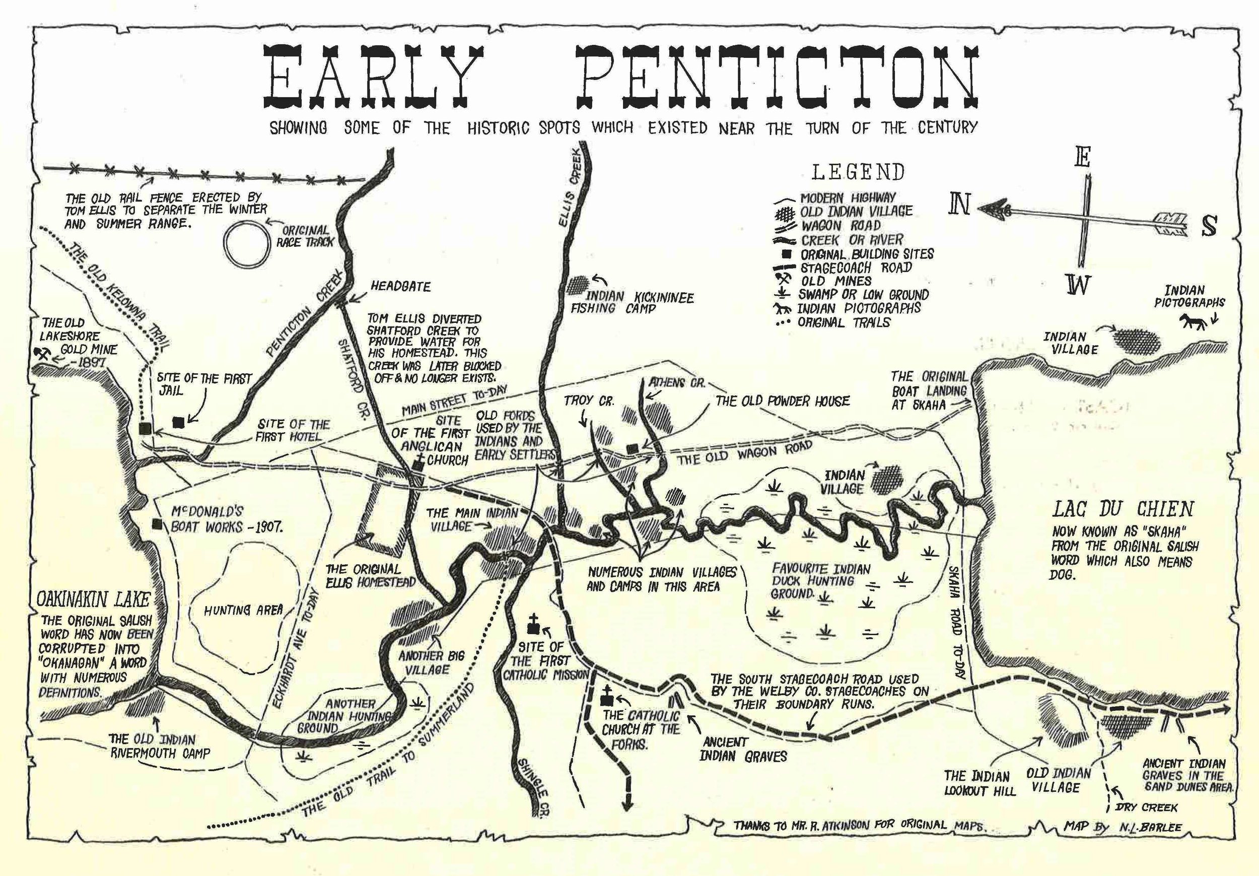
Map of Penticton Area at the turn of the 20th Century, shortly after the first stern wheeler was launched onto Okanagan Lake. (We recognize and apologize for the outdated terms used in this illustration). Map Showing: the position of the Lake shore goldmine, the old Kelowna trail, the site of the first hotel and jail, first nations land use including villages, hunting areas, salmon fishing camps. Also shown is the old wagon road, the powder house, the site of the first catholic mission and the route of the Okanagan River before the channel was cut through in the 1950’s. Map by N.L Barlee with input from R. Atkinson.
First Peoples and First Nations of the Okanagan
The history of Penticton did not start with the railways. The Okanagan people (also spelled Okanogan) have been here from the beginning. They continue to hold traditional territories stretching across the Canada and United States border, reaching into: Washington state and British Columbia in the Okanagan Country region. They call themselves the Syilx . The early 1800s was the time of first contact between present day Okanagan Indian Band ancestors and European fur traders.
To learn more about present day communities in the Valley please visit:
The Naming of the Okanagan Valley
The First Nation peoples of BC and Washington gathered here for the annual potlatch and to lay in supplies of fish and game.[1]
“Okanagan” means “rendezvous”[2]
This name was applied by the First Nation peoples to the head of the Okanagan River at Osoyoos Lake
Some say “Okanagan” also means “Big Head”. This term refers to people who have exceptional skill, valor, and other admirable qualities
“Okanagan” has been spelled at least 46 different ways[3]
Lewis and Clark spelled it “Otchenaukane” in 1805
David Thompson spelled it “Teekanoggin”, “Oackawawgan” and “Ookanawgan” in 1811, and “Ookenawkane” in 1813.
While the territory was being transferred from the Pacific Fur Company to the North West Company in 1813, it was spelled “Okunaakan”
The Arrival of European Settlers
Before gold miners began to migrate through the Okanagan to the Cariboo in July 1858, settlers, with exception of the fur-traders, had little interest in the interior of BC.[7]
In 1844, an American by the name of Robert Greenhow wrote “about the boundary to be settled between the United States and British Columbia. He mentioned the extreme irregularity of the surface of the area in dispute, and he mentioned that the obstruction of the navigation of its rivers, the removal of which was hopeless, made the possession of the vast country of no advantage to either side and not worth striving for. He also noted that there were no valuable minerals worth considering!”[8]
The Federal Government later did a very good job removing and/or marking channels around the obstructions in rivers and lakes.[9]
As late as 1959, a British journalist reported in the London Truth, “… barren, cold, a mountain country not worth keeping. About as forbidding as any country on the face of the earth.”[10]
The gold miners that struck gold in the Yale-Cariboo District became the backbone of B.C.’s interior economy.[11]
“During the sternwheel boats’ century of operation they helped, and only helped, to make possible the sudden economic expansion from a fur trading domain relying on freight canoes for river transportation to the new upward swing following the placer gold boom. Their part was to give safe and comfortable service into the mountain valleys for the settlers.”[12]
High altitude waters, such as Okanagan Lake, were considered navigable risks by CPR.[13]
The first form of transportation was foot travel.[14]
On rough slashed trails, travelers used a wheel 3 or 4 feet in diameter with 2 handles protruding ahead and behind and a man grasping each end.
This device would carry 2-3 times the load normally carried.
Horse and donkey pack trains were a favorite.[15]
Camels were brought in from the coast but they were not suited for the rocky terrain.
Other animals on the trail would flee from the camels and this caused some legal trouble between animal owners.
The valley was settled north to south.
Agriculture in the Okanagan Valley
The commercial agriculture industry in the Okanagan Valley has historically been the driving factor in the Okanagan’s economy. This occurred in two waves: first, ranchers preempted land to begin cattle farms to service the mines in the Yale-Cariboo district, and second, wheat farmers, followed by the second sons of British aristocratic families, began to move to the Okanagan to harvest fruit crops.
The first orchard was planted at Okanagan Mission in 1863 when the Oblates planted a number of apple trees. In 1875 and 1876 settlers such as George Whelan and Alfred Postill began planting orchards in the Kelowna area.[16]
No serious attempts at commercial fruit growing were made until the Earl of Aberdeen planted 200 acres at each of his farms at Guisachan Ranch (Kelowna) and Coldstream Ranch (Vernon) in 1892.[17]
By 1893, approximately 75, 000 apple trees were planted in the Yale-Cariboo district, mostly in Vernon and Kelowna.[18]
Industry slowed down significantly between late-1893 and 1900 for 4 reasons:[19]
A continental depression that began in late-1893 and lasted 5 years.
Much of the land most suitable for orchards was part of properties used for cattle ranching.
Many new orchardists held “the belief that all that had to be done was to plant the trees, which would take care of themselves, and to collect the profits.”
There was a huge problem finding and traveling to markets.
The miners of Fairview[20] and Camp McKinney provided a market for farms in the South Okanagan, but it was not big enough to support farms in the north.
Freight rates on the CPR were too expensive for farmers to afford sending their produce to other parts of Canada, notably the Prairies.
Very slowly the CPR gave into to pressure from farmers and politicians to reduce their rates:
1895 – 6 ¢/pound to ship fruit from Vancouver to Winnipeg
1899 – 2.25¢/pound to ship from Vancouver to Winnipeg
1901 – 85¢/100 pounds to ship from the Okanagan to Calgary
By 1900 the old orchards had started to produce enough fruit to show that growing fruit could be profitable.
In 1899, John Moore Robinson began promoting and selling land at Peachland to be used as fruit farms to farmers from the prairies.[21]
After the turn-of-the-century, English aristocracy began to move into the Okanagan Valley and plant orchards.
Other settlers in the area began following in Robinson’s footsteps and created an “Okanagan land boom”:[22]
R. Pooley, E. M. Carruthers and T. W. Stirling formed the Kelowna Lands and Orchard Co. (KLOC) in 1904.
South Okanagan Land Co. (SOLC) was incorporated at Penticton to buy and subdivide the Ellis estate.[23]
These lands were quickly provided with roads and irrigation and placed on the market. The land at Kelowna was priced at $100 to $200 per acre.
In 1912, many of the new orchards had come into bearing which resulted in a heavy fruit crop; unfortunately, this coincided with another heavy crop from Washington and Oregon which flooded Canadian markets. Okanagan farmers were unable to sell much fruit at their usual markets in the prairies.[24]
Land sales depleted and the land companies were left with much difficulty since few of them sold more than a third of their land.
The cooperative organization of Okanagan fruit farmers, the Okanagan Fruit Union, formed in 1908, was forced into liquidation in 1912.[25]
In May 1913, the Okanagan United Growers Ltd. Was formed and held a large portion of the market until 1923.
By 1913, Okanagan farmers were responsible for the majority of the provinces output[26]
The Valley produced over 20 million pounds in 1913, worth over $640, 000. With the 30, 000 people living in the Valley depending on success or failure of the crops, it became an important industry for the Okanagan.
Penticton
Thomas Ellis settled the Penticton area, at the South-end of Okanagan Lake, in 1865.
Penticton comes from the Sylix word “Pente-hik-ton”, which means “ever” or “forever”.[27] The name refers to the steady flow of Okanagan River.
Penticton was plotted by Ellis in the late 1880s. He petitioned the CPR to establish a wharf and station in Penticton, effectively funding the Penticton project, which they did.
The first town site plan was filed on November 15, 1892.[28]
a more extensive plan was filed on July 31, 1905
The first post office opened on December 1, 1889 and Thomas Ellis was its post master.
“The Corporation of the District of Penticton” was incorporated on January 1, 1909
The district’s first reeve was Alfred H. Wade
Penticton incorporated into a city on May 10, 1948
Its first mayor was Robert Lyon
Naramata
Naramata is on the east-side of Okanagan Lake.[29] It was named by John Moore Robinson, who was the town-site owner and founder, in 1907.
Robinson was a miner from Manitoba. When he had no luck mining, he decided to sell land to people wanting to farm fruit.
Naramata was previously called East Summerland.
Robinson claimed to get the name “from the denizens of the spirit world through the mediumship of Mrs. J. M. Gillepsie, one of the most prominent spiritualistic lecturers and mediums of the American Spiritualistic Church. Big Moose was a Sioux Indian chief, and he dearly loved his wife of whom he spoke in the most endearing terms, and he gave us her name as Narramattah, and he said she was the ‘Smile of Manitou.’ It struck me that this would be a good name for our village which I thought of calling Brighton Beach. We therefore cut out the unnecessary letters and called the town Naramata.”
Later research suggests that Mrs. Gillespie may have unconsciously remembered the name from an Australian source, as “naramatta” means “place of water” in an Aboriginal Australian dialect. Mrs. Gillespie’s first husband had lived in Australia.
The post office was opened on December 1, 1907 and its post master was J. S. Gillespie.
Gartrell’s Landing
Gartrell’s Landing (previously called Gartrell Point) is on the west-side of Okanagan Lake, just south-east of Summerland.[30]
Named after James Gartrell (1847-1930), who came to the area from Stratford, Ontario, in 1885, with his wife and five children.
Gartrell worked for Thomas Ellis for 2 years and then pre-empted land in 1887.
He became the first commercial orchardist in the Okanagan Valley.
The post office at Gartrell opened on May 1, 1910 with the post master being S. F. Sharp.
It was closed in 1914.
Summerland
Summerland is on the west-side of Okanagan Lake, [31] 11 kilometers (7 miles) north of Penticton.
It was founded and named for its climate and horticulture by John Moore Robinson, a miner from Manitoba[32]
Robinson promoted the land subdivision at the lake shore in 1902
The first post office opened on November 1, 1902
“The Corporation of the District of Summerland,” was incorporated December 21, 1906
First reeve was John Moore Robinson
West Summerland post office was opened on May 1, 1910 and its post master was James H. Ritchie.
Peachland
Peachland is on the west-side of Okanagan Lake, 32 kilometers (20 miles) north of Penticton.[33]
It was named Peachland by John Moore Robinson who promoted, subdivided and irrigated the land in 1897.[34]
Peachland was previously called Camp Hewitt. It was a mining camp named after Augustus “Gus” Hewitt, who was a prospector and logger in the early 1890s.[35]
Hewitt ran the hotel at Okanagan Landing around 1898, and, in 1901, built a new one.
The post office opened on December 1898 and its post master was D. H. Watson.
“The Corporation of the District of Peachland” was incorporated on January 1, 1909.
Its first reeve was W. A. Lang
Squally Point
Across from Peachland is Squally Point.
It is an exposed, rocky point on the east-side of the lake.
According to Native legend, the serpent N’ha-a-itk (now called Ogopogo) lives in cave in this area.
Here Ogopogo is said to have killed Chief Timbasket and his family when they canoed too close to his lair.
A light was put at the point in 1915, and was changed to a battery electric light in 1944.[36]
Gellatly
Gellatly is on the west-side of Okanagan Lake, 10 kilometers (6 miles) northeast of Peachland.[37]
Named after David Erskine Gellatly, who was a large scale vegetable and fruit grower and dealer from 1900 to 1917.
He moved from Scotland to Northern Ontario in 1883 and then to the Okanagan Valley in 1893.
He was given the titles, “Father of the produce business in the Okanagan” and “Tomato King of the Okanagan”.
He died at Vernon on March 7, 1922 at age 65.
The post office at Gellatly opened on June 1, 1903, with its first post master being C. D. Osborne.
The post office closed on June 30, 1926.
Westbank
Westbank is on the west-side of Okanagan Lake, 12 kilometers (7½ miles) southwest of Kelowna.[38]
This name was suggested around 1902 by John Davidson, who settled in the area in 1892.
The post office opened on May 1, 1892 and its first post master was N. S. Marshall.
Okanagan Mission
Okanagan Mission is on the east-side of Okanagan Lake, 10 kilometers (6 miles) south-east of Kelowna on Mission Creek.[39]
It was established in 1859 by Catholic missionaries of the Order of the Oblates of Mary the Immaculate.[40]
Okanagan Mission was the first white settlement in the British Columbian interior.
Originally the area was called L’Anse au Sable, french for “the Sandy Cove”, by fur-traders and trappers when they began moving through the Okanagan in 1812.
The first post office in the area was established on October 1, 1872, with Eli Lequime as post master.
This post office serviced the entire area until the post office in Kelowna opened.
The Okanagan Mission post office was opened on August 1, 1906, with the post master as James H. Baillie.
Kelowna
Kelowna is on the east-side of Okanagan Lake, 53 kilometers (33 miles) south of Vernon.[41]
The First Nations called the area “Nor-kwa-stin”, which is the name of a hard black rock used the by locals to sharpen flints for arrow heads.[42]
After the CPR connected the area to its railway and built a wharf, the village at the wharf was called “Kelowna” after the name the natives had given to a settler named August Gillard.
Gillard was a husky, hairy Frenchman who pre-empted land in the area in 1862. He lived in a keekwillie. One day some passing natives saw him emerge from his home, looking like a bear emerging from its den. They began to call him “Kimach touche”, which means “brown bear”. When the hub of the city began in 1892, the few white residents thought the name was too awkward so they changed it to “Kelowna” from the Okanagan word meaning “Grizzly Bear”.
The first post office opened on February 1, 1893, with its post master being Thomas Spencer.
“The Corporation of the City of Kelowna” was incorporated on May 4, 1905
The first mayor was Henry William Raymer.
Okanagan Centre
Okanagan Centre is on the east-side of Okanagan Lake, 19 kilometers (12 miles) north of Kelowna.[43]
It is now a neighbourhood of Lake Country.
The post office was opened on November 1, 1907, with J. D. Kearns as its post master.
Vernon
The Vernon area was originally called Priest’s Valley.[44] It was named after the priests of Okanagan Mission who had an out station there.
A postal office opened there in November 1884.
The name of the area was changed to Vernon in November 1887. It was named after Forbes George Vernon, the chief commissioner of lands and works for BC, who came to the area with his brother Charles in 1863.
The brothers mined at Cherry Creek in 1864 and held a land partnership with C. F. Houghton which included Cold Stream Ranch
G. Vernon eventually became to sole owner of the property
“The Corporation of the City of Vernon” was incorporated on December 30, 1892.
The first mayor was W. F. Camron
Okanagan Landing
Okanagan Landing lies on the northeast-side of Okanagan Lake.[45]
It was a settlement originally 8 kilometers (5 miles) southwest of Vernon that was developed in 1892 when the Shuswap and Okanagan Railway from Sicamous was completed, and was leased by the CPR.
Its post office was opened on October 1, 1898.
Today Okanagan Landing is an unincorporated settlement southwest of Vernon. The decommissioned land was bought by the Okanagan Landing & District Community Association in 1971.
Wilson’s Landing
Located on the mid-west-side of Okanagan Lake[46]
It is named after Harold Fitz-Harding Wilson, who settled the area in 1900.
The post office opened on August 1, 1908 and Miss Marion Violet Harvey Goodcare was its first post master.
Goodcare later became Mrs. George Cecil Browse.
Caesar’s Landing
Located on upper-west-side of Okanagan Lake.[47]
It is named after Northcote Henry Caesar: the first settler who came to the area in May 1893.
In the 1890s Caesar built a steamer launch, the Wanderer. A 39½ foot long steamboat, using the 5 H.P. engine from the S. S. Mud Hen, which first came from the Mary Victoria Greenhow, the first steamship on Okanagan Lake.
Bruce’s Landing
Located on the upper-west-side of Okanagan Lake (between Shorts’ Point and Ewing’s Landing).[48]
It is named after James Baxter Bruce who settled in the area in the 1890s.
According to Captain J. B. Weeks, a quirk of Bruce’s religiosity was “to write letters and post them on the boat without stamps, generally asking the purser to put stamps on them and the Lord would bless him.”
The post office opened on February 1, 1898, with William Seivewright as its post master.
It was closed on November 30, 1902.
Ewing’s Landing
Located on the upper-west-side of Okanagan Lake, 3 kilometers (2 miles) north of Shorts’ Point.[49]
Named after Robert Leckie Ewing, a resident in the area since the 1900s.
The Shorts’ Point post office was changed to Ewing’s Landing on December 1, 1907.
The first post master was E. C. Chamney, but Ewing took it over on May 1, 1908
Killiney
Located on the upper-west-side of Okanagan Lake, approximately 5 kilometers (3 miles) north of Shorts’ Point.[50]
Named after the Hill of Killiney, Monkstown, Co. Dublin, Ireland, by Harry Percy Hodges (d. 1922) who settled in the area in 1903.
Hodges had previously been a bookkeeper at Coldstream Ranch.
He married Arabel M. Ricardo, the sister of William Crawley Ricardo, manager of Coldstream Ranch from 1895 to 1914.
Nahun
Located on the upper-west-side of Okanagan Lake.[51]
Named by Howard Bruce Kennard after Nahun Wenox, “child of the rock”, a character in an First Nation’s legend which told the story of the little rock island across from Nahun. The island was said to have originally been part of the big rock just north of the Nahun wharf.
Nahun’s former name was “The Golden Gate”.
It was named by HBC fur traders because packers on the Brigade Trail would put up a barricade here and camp behind it so as to keep their horses from wandering off.
The post office at Nahun opened on August 1, 1905, with Kennard as its post master.
Carr’s Landing
Located on the upper-east-side of Okanagan Lake.[52]
Named after Andrew Carr, a settler who lived in the area from 1895 until his death in 1910.
Its post office was opened on July 1, 1909 and closed on July 14, 1939.
The first post master was Peter Sinclair.
The name of Carr’s Landing later became Sunnywold.
[1]Harvey, “Okanagan Place Names:” 213.
[4]Harvey, “Okanagan Place Names:” 214.
[7]Captain Otto L. Estabrooks, Sternwheel Boats in British Columbia (Penticton, Canada, 1968), 6.
[10]Quoted in Estabrooks, Sternwheel Boats in British Columbia, 6.
[21]Dendy, “The Development of the Orchard Industry in the Okanagan Valley, 1890-1914:” 29.
[24]Dendy, “The Development of the Orchard Industry in the Okanagan Valley, 1890-1914:” 29.
[26]Dendy, “The Development of the Orchard Industry in the Okanagan Valley, 1890-1914:” 30.
[27]Harvey, “Okanagan Place Names:” 216.
[32]Harvey, “Okanagan Place Names:” 214.
[39]Harvey, “Okanagan Place Names:” 214.
[41]Harvey, “Okanagan Place Names:” 207.
[43]Harvey, “Okanagan Place Names:” 214.
[44]Harvey, “Okanagan Place Names:” 222.
[47]Harvey, “Okanagan Place Names:” 200.
[52]Ibid: 221. Carr’s Landing is under the name Sunnywold.
More information
The members of the crew are happy to answer any questions, and if they do not know the answer will be happy to direct you to someone who does!
Finding History Books and Articles
If you would like to research the history of the Okanagan lake ships under your own steam, there are plenty of books available to you, and the local Penticton Library has an extensive local history section. Click here to see the online catalogue: The Penticton Library
More Reading (Online History Collections)
The Okanagan Historical Society has an extensive collection of articles about the Sicamous, the lake boats, and life in the early Okanagan (the lives of 20th Century European settlers). The collections have been digitized and can be accessed for free from the University of British Columbia’s online collections. Click here to see the online collections from the Okanagan Historical Society: Okanagan Historical Society
Archive Photos
For archive photos of the lake ships you can contact the Penticton Museum and Archives. This is in the same building as the Penticton Library, so you can easily combine a visit to the museum, archives and library too. Many of the photos in the collection are already digitized and can be searched in-house, on the archive collections computer. The archives are open from Wednesday to Friday( 10am to 4:30pm) . Booking a visit in advance is highly recommended, as it means the archives volunteers can find the information you need, ahead of your visit. To book a visit, or to learn more please call: 250-490-2453.
Extra Information for Teachers
Have a look at the Canadian Pacific Rail History Teaching Pack – Canadian Pacific Rail Children’s Information Pack .
Join the Mailing List
Never miss out on news from the SS Sicamous Society
News and sneak peaks will be delivered straight to your inbox