Carmi B.C.
Carmi BC is located at an elevation of 2885 ft above sea level, and 251miles (403.9 km) from Hope on the Kettle Valley Railway and is part of the Carmi-Subdivision of the CP Railway.
Carmi Subdivision – Penticton to Myra
This is probably the most famous section of the Kettle Valley Railway because it has the Myra Canyon in it. The Myra Canyon is located near Kelowna and is easily accessible via car or bike to either end of the canyon. Once there, you can easily walk or bike the 12 kilometer section of rail bed that crosses 18 bridges and goes through 2 tunnels. Unfortunately in 2003, 16 of the 18 trestles were destroyed by fire. They have since been rebuilt and this section of the railway re-opened to the public.
Carmi is a hamlet in the Boundary Country region of southern British Columbia. The town is on the west side of the West Kettle River, east of Penticton, on Hwy 33.[2] Carmi emerged as a silver mining camp just after the turn of the 20th century, named after the nearby mine owned by James C. Dale from Carmi, Illinois.[3]
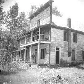
By 1910, Carmi comprised crude log cabins and a hotel owned by "Trapper" Smith. In 1931 forest fires did an extensive amount of damage to the tracks near Carmi.
When the mine closed, the town mostly disappeared after three decades of existence.[4] Passenger train service ceased in the early 1960s. The abandoned Smith House hotel burnt to the ground in 2000.[5]
Some of the trestles that were erected along the Myra Canyon, were framed first in Carmi and then transported to the end of the rail line for assembly. The KVR generated work for over 75 blacksmiths in Carmi.
Photograph taken by David Davies.
This is a photo of a now abandoned hotel, once very popular in Carmi. BC during the construction of the KVR.


