Kettle Valley Railway Maps
The Kettle Valley Railway in Penticton
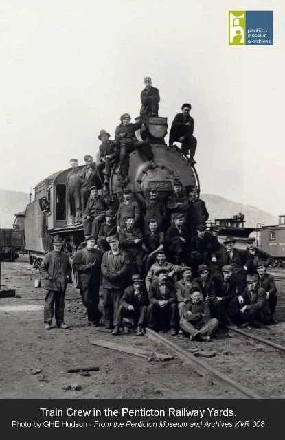
Did you know? Penticton was once the head quarters of the Kettle Valley Railway (KVR). This bustling railway town boasted two stations, a wharf connecting with the steam ships, and its own luxury railway hotel. The trains have long since stopped running, but the legacy of the railways continues to this day. Learn more about Penticton & the KVR.
The KVR trail is now a popular hiking destination for tourists and locals alike. You can follow the walking trail through Summerland, Penticton, Naramata and Kelowna too. If you are feeling adventurous, the path also connects with the Trans Canada Trail, spanning the whole of the country.
Map of the walking routes in courtesy of the Visitor Information centre, at 553 Vees Drive Penticton. They will be happy to provide more information about hiking and biking options in the local area.
How to find the start of the Kettle Valley Rail (KVR) Trail in Penticton
Accessing the walking trail is easiest from Vancouver Avenue, Penticton.
Directions: Head up Vancouver Avenue and turn left onto Vancouver Place. Continue to the end of the cul-de-sac and you will see the start of the trail. See below for a Google Maps link to the area.
-

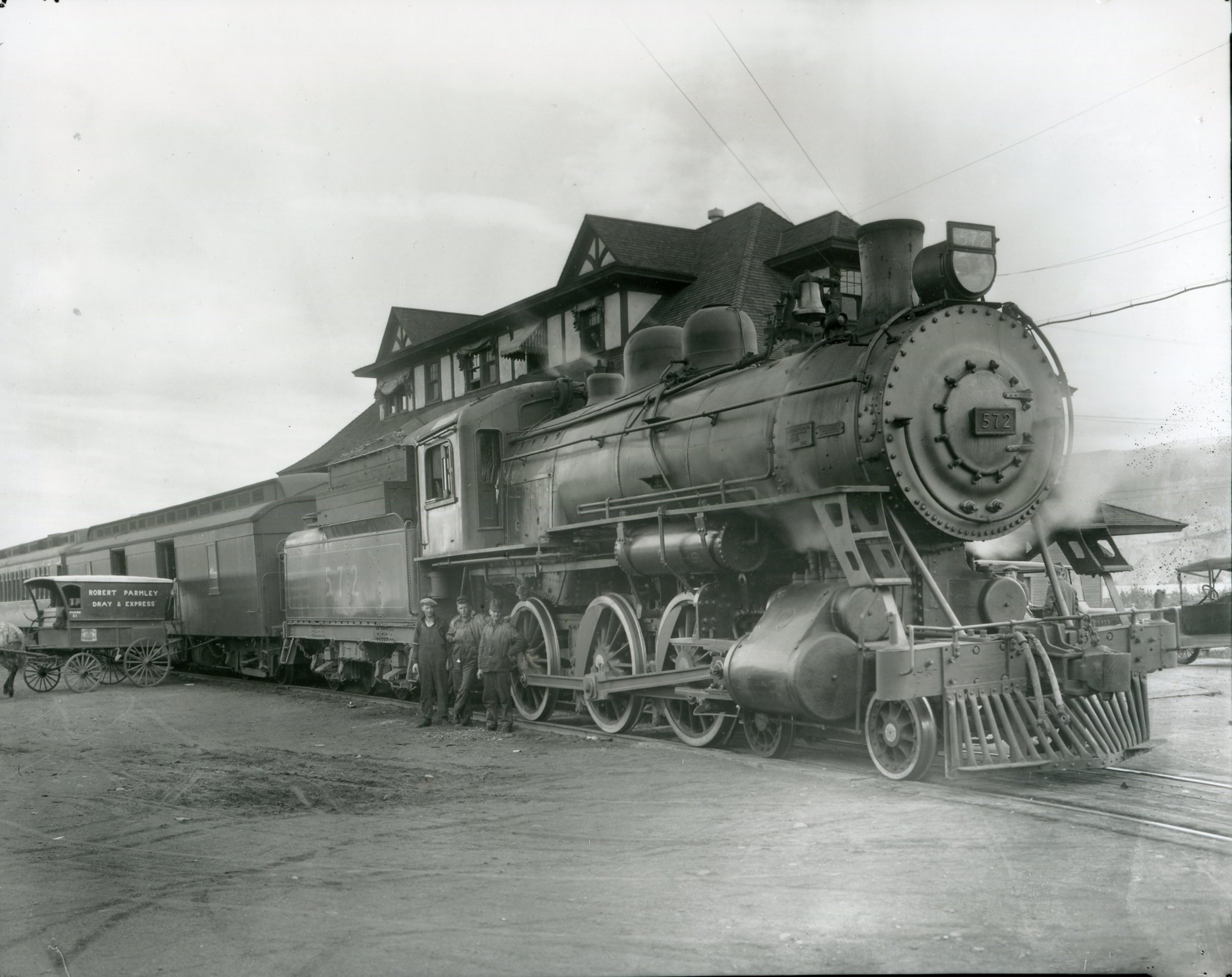
The first KVR passenger train pulls into the Penticton railway station
(June 31st 1915). The railway station was beside the wharf, at the base of Martin Street (close to where the Peach is today). Photo from the Penticton Museum and Archives.
-

The Penticton KVR Railway Station
As seen from the bow of a stern wheeler (possibly the SS Sicamous!) Photo is from the Penticton Museum and Archives.
-
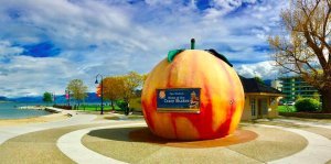
The Location of the Original Penticton Railway Station
The Iconic Penticton Peach sits close to where the original railway station and docks were located. Next time you are at the beach, take a moment to picture the busy railway wharf, with stern wheelers and tugs ready to depart.
-
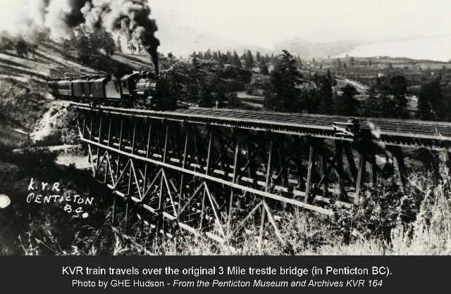
The original KVR.
The original KVR. A steam engine travels over the original Three Mile Trestle Bridge. The bridge has been restored and is part of the walking trail from Penticton.
How to find the Penticton KVR Trail on Google Maps
Start by entering the postcode V2A 1A7 into google, Then change the mode of transport to "walking", and the start of the trail will become visible.
To open the maps in your browser, click the "more options" text
Google Map of KVR Cycle Route from Penticton to Naramata
This is a much longer trip, more suitable for cyclists. To open the maps in your browser, click the "more options" text.
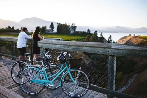
The trail is at an elevation of 598 meters (1955 feet) and is 20.6 km (12.8 miles). It can be a relaxing walk or bike ride with spectacular views. It takes about 4 hours to bike a round trip. Start at Vancouver Place, Penticton, and continue to all the way to Naramata. Along the way, you will see panoramic views of Okanagan Lake, stop along the way at the many quaint, famous Okanagan vineyards and wineries. You can also keep going to reach the Naramata Little Tunnel, where the KVR trail officially connects with the Trans Canada Trail.
Steam engine passes through the Little Tunnel Look Out in Naramata, BC. This location is on the KVR trail and has stunning views of the area.
View from the Naramata Little Tunnel look out. Learn More about hiking to the Naramata Little Tunnel
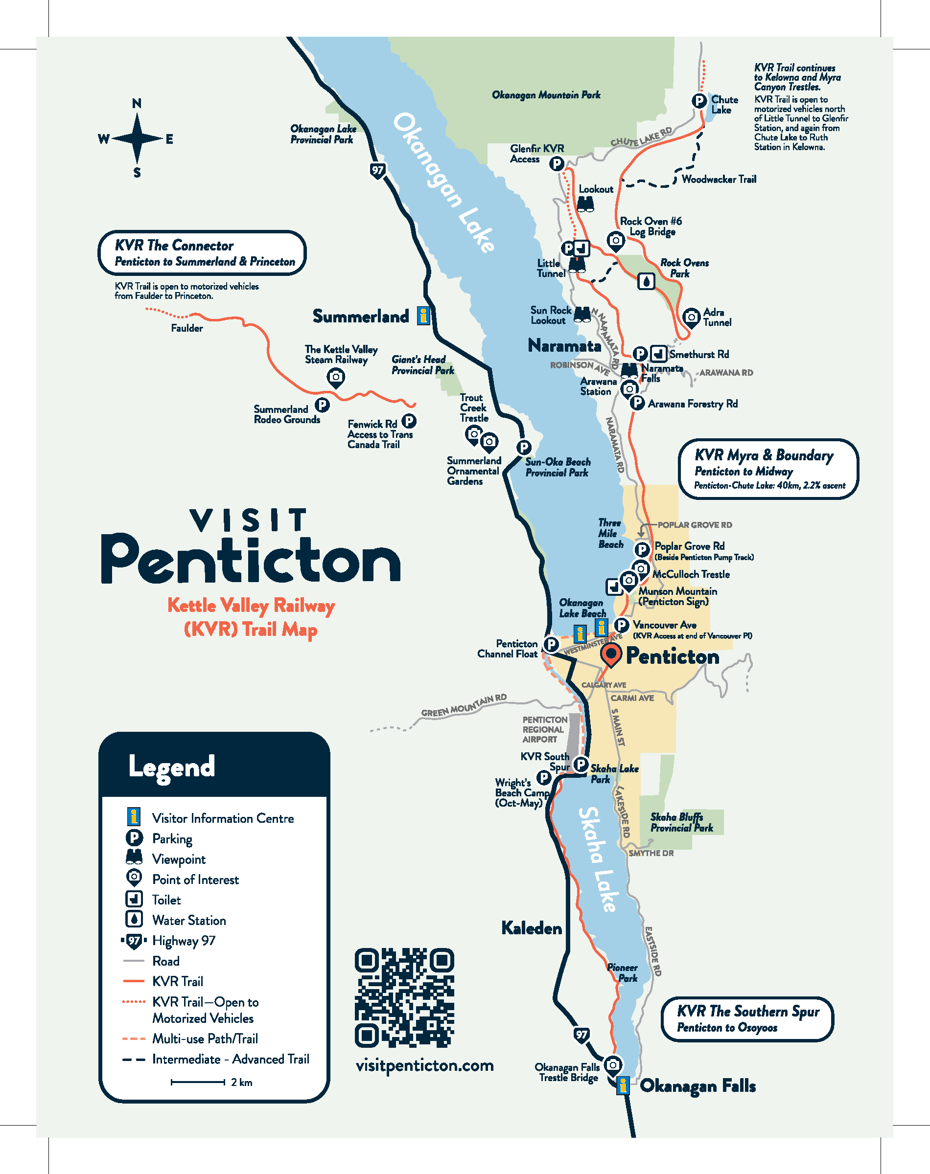
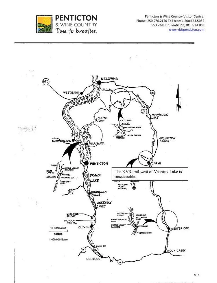
Printable Map
Printable map of the KVR route from Penticton to Chute Lake, via Naramata ana the Little Tunnel. Map courtesy of the Penticton Visitor Information Centre.
Map features: the McCulloch Trestle, the Arawana Water Tower Gazebo, Smethurst Parking lot, the Adra Tunnel bypass Trail, the Water tower and house, rock overs 4 and 5, Glenfir Loop and wood wacker trail.
KVR Trail from Penticton to Chute Lake, showing the Adra Tunnel bypass Trail, the Water tower and house, rock overs 4 and 5, Glenfir Loop and wood wacker trail.
Travel Penticton KVR Map
More ways to explore & enjoy the Kettle Valley Railway
-
![]()
Working Model KVR Railway
See the Kettle Valley Railway in Miniature. An immense scale model of the Kettle Valley Railway covers much of the cargo deck on the SS Sicamous. The model shows the entire route of the KVR from Midway, through Penticton and on to Hope. Visit the Museum
-
![]()
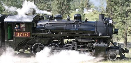
Restored KVR Steam Engine in Summerland BC
Ride on a Steam Train in Summerland BC. A section of the original KVR railway tracks has been preserved. A restored 1912 steam engine offers trips in the summer. The trains are looked after by volunteers. Check the website for train schedules. The Kettle Valley Steam Railway - Summerland, BC


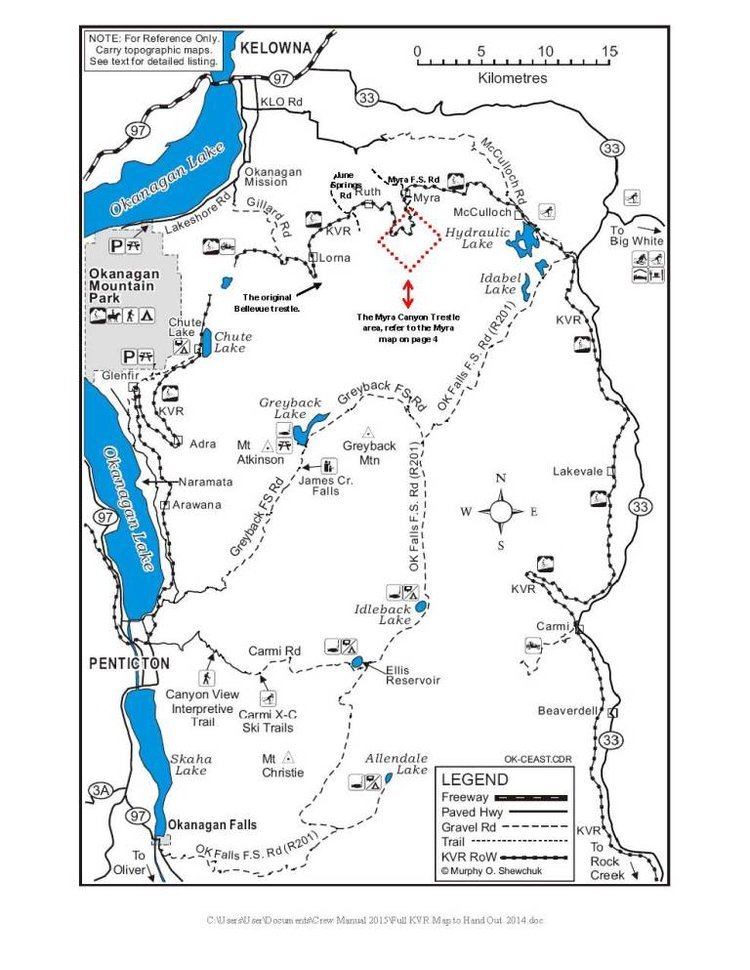
More to see. Printable Maps and Routes of the Kettle Valley Railway in the Okanagan
Courtesy of Penticton and Wine Country Visitor Centre
Click the map to enlarge and print! Copies are also available from the Penticton Visitor Information Centre
Printable map of the KVR trails from Osoyoos B.C
The two maps below include Kelowna, McCulloch Road, Hydraulic Lake, Arlington Lakes, Carmi, Westbridge, Rock Creek, Osooyos, Oliver, Okanagan Falls, Skaha Lake, Penticton, Naramata, and Chute Lake.
Printable map of the KVR trail in Oliver BC. >
Map shows the Kettle Valley Rail Trail (KVR) from in Oliver BC. If visiting Oliver, you can find the Tourism Information centre in the old CPR Railway Station house, just south of Lions Park. It is right on the walking and hiking trails.
Map features: Kinsman Park, Kiwanis Park, Lions Park, Rotary Beach, Kiwanis Desert Oasis Picnic Park.
Click the map to enlarge and print! Copies are also available from the Penticton Visitor Information Centre
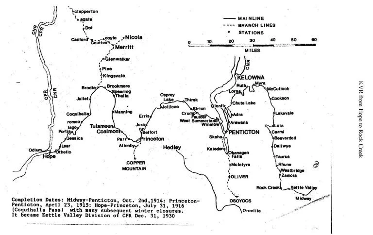
< Full Printable Map of the Kettle Valley Railway Route from the Kootenays to Coast.
Printable Map of Printable map of the 8.5km section of the Kettle Valley Railway (Carmi Subdivision) containing 18 trestles and two tunnels. >
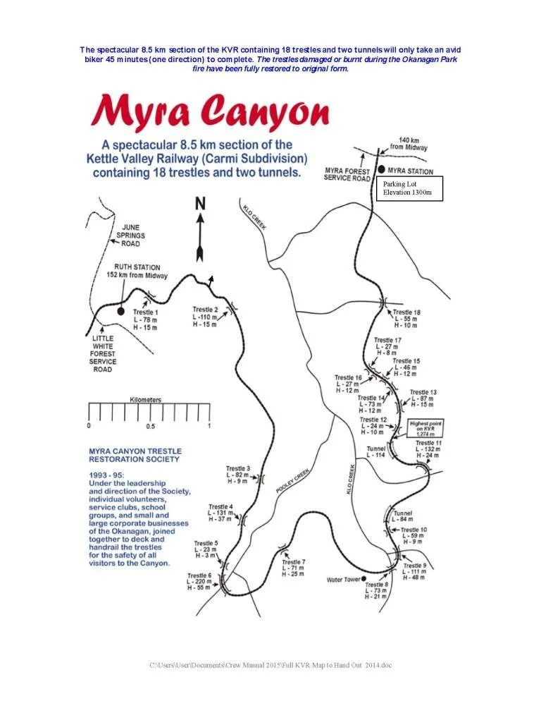
KVR Trail from Penticton to Myra Canyon Trestles
KVR Trail from Naramata to Myra Canyon Trestles (Kelowna)
Kettle Valley Railway Trail – Princeton to Penticton
The Role of the KVR in Penticton
Did you know? Penticton was once the headquarters of the Kettle Valley Railway (KVR). This bustling railway town boasted two stations, a wharf connecting with the steam ships, and its own luxury railway hotel. The trains have long since stopped running, but the legacy of the railways continues to this day.
The KVR trail is now a popular hiking destination for tourists and locals alike. You can follow the walking trail through Summerland, Penticton, Naramata and Kelowna too. If you are feeling adventurous, the path also connects with the Trans Canada Trail, spanning the whole of the country.
Learn more about the Railway Heritage of Penticton and the Okanagan